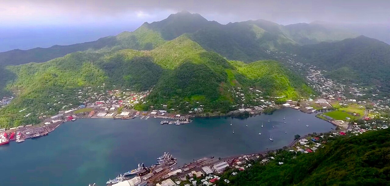
Pago Volcano: A Geological Marvel in Papua New Guinea
Nestled within the volatile tectonics of the Pacific Ring of Fire, Pago volcano stands as a prominent geological feature on the island of New Britain, Papua New Guinea. This active stratovolcano, often characterized by its distinctive dacitic shield, represents a fascinating interplay of volcanic processes. While its name might occasionally lead to confusion with other public figures, for geologists and local communities, Pago unequivocally refers to a powerful natural force that has shaped the landscape and history of the region.
The geological setting of Pago is particularly intriguing. It is part of the larger Witori caldera complex, an older, pre-caldera volcano that likely exhibited a low-angle, dominantly pyroclastic structure. Following a catastrophic eruption and subsequent collapse that formed the caldera, Pago began to grow within or on its flanks, eventually developing into the edifice we see today. Unlike many classic shield volcanoes, which are typically composed of fluid basaltic lavas, Pago is distinguished by its dacitic composition. As noted by Cook (1981), its silica content hovers around 66%, placing it firmly in the dacite range. This higher silica content generally implies more viscous lavas and potentially more explosive eruption styles compared to basaltic shields, yet Pago manages to maintain a shield morphology, albeit one distinct from its Hawaiian counterparts.
Unpacking the 2002 Pago Eruption: A Detailed Account
The year 2002 marked a significant chapter in Pago volcano's recent history, as it sprang to life with a series of effusive and explosive events. The eruption, which began on August 5, 2002, was not entirely unexpected, as it had been preceded by approximately one month of discernible seismic activity. This crucial pre-eruptive unrest served as a vital warning sign, highlighting the indispensable role of continuous seismic monitoring in anticipating volcanic events.
Initial phases of the eruption, as recounted by local eyewitnesses, involved "about ten times of puffing of volcanic ash." This description suggests a series of intermittent, relatively small-scale explosive events, possibly phreatic (steam-driven) or phreatomagmatic (magma-water interaction) eruptions, which are common precursors or accompaniments to larger magmatic effusions. These ash puffs would have served to clear the vent and signal the ascent of magma towards the surface.
Following these initial ash emissions, the eruption primarily transitioned into an effusive phase, characterized by the outpouring of dacitic lava. While dacitic lavas are typically more viscous than basalt, they can still form extensive flows, particularly if the eruption rate is sustained and the topography allows. The effusive nature of the 2002 eruption further solidified Pago's classification as a dacitic lava shield, demonstrating its capacity for sustained lava extrusion.
The eruption quickly drew international attention and collaboration. From August 25 to September 3, 2002, a specialized observation team, comprising two seismologists, Dr. K. Uhira and Dr. A. Takagi from the Japan Meteorological Agency (JMA), and a geologist, Dr. Mitsuhiro Yoshimoto from the University of Tokyo, was dispatched to the Pago volcano. This mission, undertaken in the spirit of friendly relations between Papua New Guinea and Japan, was crucial for on-site assessment and data collection. The team received vital support from the Rabaul Volcano Observatory (RVO) in Papua New Guinea and governmental agencies from both countries, including the Japan International Cooperation Agency (JICA). Such international partnerships are fundamental in volcano monitoring, pooling expertise and resources to better understand and respond to volcanic crises. The detailed findings and observations from this eruption were subsequently compiled and prepared by the RVO, serving as invaluable data for future risk assessment and scientific research.
The Dacitic Shield of Pago: Contrasting Morphologies
The morphology of Pago volcano presents a compelling study in geological contrasts. Its current form as a post-caldera lava shield stands in striking opposition to its predecessor, the Witori volcano. The pre-caldera Witori was described as a low-angle, dominantly pyroclastic structure. This implies that Witori likely built up over time through explosive eruptions, depositing layers of ash, tephra, and pyroclastic flows, potentially forming a large stratovolcano or a similar edifice with a broad base. The collapse of such a structure following a major eruption would have created the caldera that now hosts Pago.
In contrast, Pago itself has developed as a "dacitic lava shield." This classification is particularly interesting because traditional shield volcanoes, such as those in Hawaii, are typically associated with highly fluid basaltic lavas that flow easily, creating broad, gently sloping profiles. Dacite, with its higher silica content (around 66% SiO2 for Pago), is inherently more viscous. This viscosity means that dacitic lavas tend to flow less readily, often forming thicker, shorter flows or building steeper-sided domes and stratovolcanoes.
So, how does a dacitic volcano form a "shield"? There are several interpretations and implications:
- Relative Definition: The term "shield" for Pago might be used in a relative sense, describing an edifice that is broader and has gentler slopes than typical dacitic stratovolcanoes or lava domes, even if its slopes are steeper than basaltic shields.
- Eruption Dynamics: Sustained effusive eruptions over long periods, coupled with a relatively consistent supply of magma, could still allow dacitic lavas to build a broad structure, especially if individual flows are voluminous.
- Erosional Factors: The overall appearance might also be influenced by erosional processes over geological time, softening the slopes of what might have been a more complex initial structure.
The unique dacitic composition of Pago's lavas means that while it behaves somewhat like a shield volcano, its eruptions can carry a greater potential for explosivity than basaltic counterparts. Understanding this morphological and compositional contrast is key to appreciating Pago's specific volcanic hazards and its place in the diverse world of volcanoes.
Monitoring and Mitigating Volcanic Risks at Pago
Living in the shadow of an active volcano like Pago requires constant vigilance and robust monitoring systems. The 2002 eruption underscored the critical importance of early warning and international cooperation in managing volcanic risks. The Rabaul Volcano Observatory (RVO) plays a pivotal role in this regard, not just for Pago but for many active volcanoes across Papua New Guinea.
Effective volcano monitoring relies on a suite of scientific techniques:
- Seismicity: Tracking earthquakes and tremors beneath the volcano is paramount. The month-long seismic activity preceding the 2002 eruption at Pago clearly demonstrated its value as a precursor. Networks of seismometers detect changes in magma movement and crustal stresses.
- Ground Deformation: Changes in the volcano's shape (inflation or deflation) can indicate magma accumulation or withdrawal. Techniques like GPS measurements and InSAR (Interferometric Synthetic Aperture Radar) can detect ground deformation with millimeter precision.
- Gas Emissions: Volcanic gases (sulfur dioxide, carbon dioxide, hydrogen sulfide) are released as magma rises. Monitoring changes in gas composition and flux can provide clues about magma depth and activity.
- Thermal Imaging: Satellite or aerial thermal imaging can detect increases in heat flow, indicating new lava flows or hot spots.
Beyond scientific observation, community engagement and preparedness are vital for mitigating risks. Local authorities, in collaboration with institutions like RVO, work to:
- Develop Evacuation Plans: Clearly defined routes and shelters are essential.
- Conduct Awareness Campaigns: Educating residents about volcanic hazards, alert levels, and what to do in an emergency is crucial.
- Establish Communication Channels: Reliable systems for disseminating warnings and information to remote communities.
Practical Tip for Communities near Active Volcanoes: Always have an emergency kit ready, including water, non-perishable food, first-aid supplies, a flashlight, and a battery-powered radio. Familiarize yourself with local evacuation routes and meeting points. Understanding the different alert levels issued by monitoring agencies can empower individuals to make informed decisions for their safety.
Understanding Pago's Place in Pacific Ring of Fire Volcanism
Pago volcano is more than just an isolated peak; it is an active participant in the dynamic geological processes of the Pacific Ring of Fire. This horseshoe-shaped belt around the Pacific Ocean is famed for its intense seismic and volcanic activity, home to approximately 75% of the world's active and dormant volcanoes and the site of 90% of the world's earthquakes.
The existence of the Ring of Fire is fundamentally linked to plate tectonics, specifically the subduction zones where oceanic plates are forced beneath continental or other oceanic plates. As the oceanic plate descends into the Earth's mantle, it melts, forming magma that then rises to the surface, fueling volcanic eruptions. New Britain, where Pago is located, lies on such a complex plate boundary, making it inherently volcanically active.
Pago's dacitic composition makes it an interesting case study within this larger context. While many volcanoes in subduction zones are stratovolcanoes producing andesitic to dacitic lavas, Pago's shield-like morphology distinguishes it. This highlights the incredible diversity of volcanic types that can arise from similar tectonic settings, influenced by factors such as magma composition, eruption rates, and the local crustal structure. Studying volcanoes like Pago provides valuable data for geoscientists to:
- Refine Models of Magma Generation: Understanding why dacitic magma forms and erupts in a shield-like fashion.
- Improve Hazard Assessment: Learning how to predict and mitigate the unique risks posed by dacitic effusive and potentially explosive eruptions.
- Advance Tectonic Theory: Gaining insights into the specific interactions of plates beneath this part of the Ring of Fire.
The ongoing scientific investigation of Pago volcano contributes not only to the safety of local populations but also to a broader understanding of Earth's powerful internal processes and the complex ways they manifest on the surface.
In conclusion, Pago volcano is a compelling example of an active dacitic shield volcano within the intensely dynamic geological setting of Papua New Guinea's segment of the Pacific Ring of Fire. The 2002 eruption, characterized by seismic precursors, initial ash puffing, and subsequent lava effusion, offered crucial insights into its eruptive behavior. Its unique morphology, contrasting with the pre-caldera Witori and other dacitic volcanoes, underscores the complexity of volcanic evolution. Through continued monitoring by institutions like RVO and vital international collaborations, understanding and mitigating the risks posed by Pago remain a priority, ensuring the safety of communities and contributing to the global scientific endeavor to unravel the mysteries of our planet's fiery heart.